
1927 Partial Map of the Village
of Center Line, Michigan
The maps below are one-fourth of a set of maps that were created in February of 1927 for fire insurance rating purposes in anticipation of the planned installation of water mains and fire hydrants later that year. This section includes a small scale map of all the streets in the village, plus a larger scale map showing the lots and houses on Central and Harding Avenues.
Here are some interesting details and recollections:
the village population in 1927 was 3,333 individuals
the fire department was located at the rear of 152 Engleman Avenue, just west of Van Dyke Ave. - it had one paid fireman and 20 partly paid volunteers (see photo below)
water facilities were to be installed later in 1927 and would include a well and standpipe at 10 Mile Rd. and Landau Ave., 14 miles of water pipe and 34 fire hydrants.
there were only 3.5 miles of paved streets within the village limits
Clement Grobbel and his family lived in the house at 127 Central Ave. (identified as number 215 on this map, which was an arbitrary number used by the mapmaker). This was on Lot 114 of the "H. Renshaw's Center Line Subdivision" and their house was the ninth one west of the northwest corner of Evelyn and Central Avenues.
Other families who lived on the north side of Central Ave. included: Tharret (Lot 127), Lietz (Lot 124), Tony Schimmel (Lot 121), Hall (Lot 120), Phaneuf (Lot 117), Rudy Wilke (Lot 115) and Ed and Roxanna Carney (Lot 113).
Dale Ave. did not yet intersect with Van Dyke Ave from the east.
the "Clement Grobbel Cement Block Mfg." was located south of Dale Ave. at the rear of Lots 133 & 134. The garage-type structure at the rear of Lot 133 still stands today. The structure at the rear of Lot 134 was later torn down and the materials used in the construction of the house Clem built on Lot 133 beginning around 1935.
the smaller scale street map of the entire village indicates that:
Mackersie Rd. was shown just a half-block to the north of, and paralleling, Helen Ave., between Lawrence and Van Dyke Avenues, however, if it was ever constructed, it no longer exists
some of the street names shown on the map have changed over time: St. Clement Ave. became Stephens Rd., Church Road became Engleman Ave. (east of Van Dyke), Meyer became Arsenal Ave., Wilson became Busch Ave., Lincoln became Menge Ave. and Washington became Potomac Ave.
(Click on map image to enlarge)

(Click on map image to enlarge)
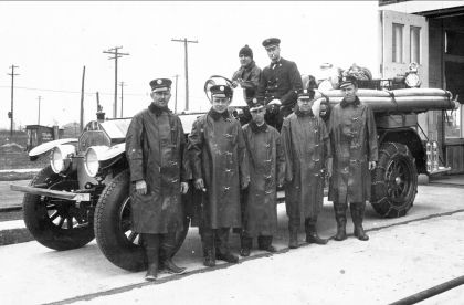
Village of Center Line, Michigan
Volunteer Fire Department members shown in
front of their 1926 American La France Pumper. This photo was
probably taken
during the winter of 1928-1929.
Seated: Nelson Zott (behind steering wheel), Chief George Theut.
Standing (left to right): Mark Kunath, Bert Grobbel, Andrew
Wiegand,
Harold Stilwell, Edward Grobbel.
Next:
The Village of Center Line, Michigan - 1932 Partial Maps,
Facts and Photos
Return:
Center Line, MI
Historical Information - Home Page
For more information:
History of the City of
Center Line - Center Line Municipal Web Site